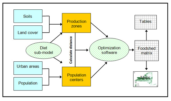
The theoretical capacity to supply the food needs of population centers is based on the agricultural land productivity of underlying soils and contemporary crop yields. Specifically, existing geographic data on soils, land cover, urban areas, and population were integrated with a sub-model that estimated land requirements of the human diet (called the Foodprint Model). Together, these data were used to characterize the food production potential of the land base, divided into production zones, and the food needs of its people, clustered in population centers. This information was fed into an optimization model to determine the amount of food, measured in Human Nutritional Equivalents, each population center would receive from each production zone. Food distribution between production and consumption were optimized for the minimum number of food miles. The output from this Foodshed Model, a foodshed matrix, provides the data used to map potential local foodsheds shown in the Foodshed IMS.
A simplified schematic of the methodology is shown below in the figure. For more details on this methodology or the Foodprints and Foodsheds Models, please see the materials in the Publications tab located on the main page of this website. Similarly, Foodshed Model terminology is defined below.
Human Nutritional Equivalents (HNE): The amount of food needed to meet all nutritional requirements for the average consumer for one year. According to the diet used in the Foodshed Model, one HNE weighs 2,750 lbs, provides 2,300 kcal/day, and contains representatives from all major food groups: grains, fruits, vegetables, dairy, protein, added fats, and sweeteners. The nutritional requirements for the “average” person were determined based on recommended intake for different age/gender groups and the population demographics.
Population centers: In the Foodshed Model, a population center is an urbanized area or urban cluster as defined by the U.S. Census Bureau. The model assumes that rural residents will obtain their food from the nearest population center.
Production zones: For the purposes of the model, the land area needed to be divided into discrete units. These units, called production zones, are 5 by 5km in area and have an estimated capacity for producing food based on the amount of agricultural land they encompass and the productivity of the underlying soils.